Jan 25th storm

Anonymous
Anonymous wrote:
Anonymous wrote:
Anonymous wrote:
Anonymous wrote:
Anonymous wrote:Any updates to the forecast yet today?

GFS model, which was the outlier that had the storm running to the south (meaning little to no accumulation) has updated and is now tracking higher snow totals similar to other models.


So 2 feet or so?


Currently showing 16 in within the beltway IF its all snow and not a mix.

Doug K, who won't forecast until tomorrow, has at least said whatever it is, it will come as snow.

weather apps are still saying saturday 6pm for us.
Anonymous
Anonymous wrote:Is there any consensus on when this is supposed to start? Or still too early?

Still too early, but the current consensus is Saturday mid-to-late afternoon.
Anonymous
Anonymous wrote:
Anonymous wrote:
Anonymous wrote:
Anonymous wrote:Any updates to the forecast yet today?

GFS model, which was the outlier that had the storm running to the south (meaning little to no accumulation) has updated and is now tracking higher snow totals similar to other models.


So 2 feet or so?


Currently showing 16 in within the beltway IF its all snow and not a mix.


How could we even get a mix with how cold the temps will be?
Anonymous
Anonymous wrote:
Anonymous wrote:
Anonymous wrote:
Anonymous wrote:
Anonymous wrote:Any updates to the forecast yet today?

GFS model, which was the outlier that had the storm running to the south (meaning little to no accumulation) has updated and is now tracking higher snow totals similar to other models.


So 2 feet or so?


Currently showing 16 in within the beltway IF its all snow and not a mix.


How could we even get a mix with how cold the temps will be?


I think they ruled out a mix. It's snow, the question is how much.
Anonymous
OP here.

Nothing is ruled out because we're only Wednesday, except the option of no precipitation at all

We are getting a winter storm for sure.

There is a run of models that give us freezing rain and sleet after an early accumulation of snow, which would be disastrous for our power lines and cause widespread power outages. Hopefully this run of models is wrong. All other runs are teetering between 6 and 18 inches of fluffy snow for DC, with various start times between Saturday evening and overnight.

It's still too soon to lock into a prediction. At the earliest, we can lock in tomorrow Thursday.

But yeah... go shopping for necessities, and don't empty the whole store. It's no use buying two entire carts of toilet paper, OK?


Anonymous
Anonymous wrote:OP here.

Nothing is ruled out because we're only Wednesday, except the option of no precipitation at all

We are getting a winter storm for sure.

There is a run of models that give us freezing rain and sleet after an early accumulation of snow, which would be disastrous for our power lines and cause widespread power outages. Hopefully this run of models is wrong. All other runs are teetering between 6 and 18 inches of fluffy snow for DC, with various start times between Saturday evening and overnight.

It's still too soon to lock into a prediction. At the earliest, we can lock in tomorrow Thursday.

But yeah... go shopping for necessities, and don't empty the whole store. It's no use buying two entire carts of toilet paper, OK?


You migh recall that we received 1-3" last weekend. According to the weather experts, it evaporated before it made it the ground. But their predictions were 100% correct.
Anonymous
Anonymous wrote:
Anonymous wrote:OP here.

Nothing is ruled out because we're only Wednesday, except the option of no precipitation at all

We are getting a winter storm for sure.

There is a run of models that give us freezing rain and sleet after an early accumulation of snow, which would be disastrous for our power lines and cause widespread power outages. Hopefully this run of models is wrong. All other runs are teetering between 6 and 18 inches of fluffy snow for DC, with various start times between Saturday evening and overnight.

It's still too soon to lock into a prediction. At the earliest, we can lock in tomorrow Thursday.

But yeah... go shopping for necessities, and don't empty the whole store. It's no use buying two entire carts of toilet paper, OK?


You migh recall that we received 1-3" last weekend. According to the weather experts, it evaporated before it made it the ground. But their predictions were 100% correct.


But this is not the same climatological set-up at all. We're dealing with a heck ton of moisture coming from the Pacific ocean that is crossing the entire US and transforming into snow, thanks to cold air coming down from Canada just at the right time. Basically it's a moisture transfer from Pacific to Atlantic that skip hops across a continent. It's pretty impressive.
Anonymous
Anonymous wrote:
Anonymous wrote:
Anonymous wrote:
Anonymous wrote:
Anonymous wrote:
Anonymous wrote:Any updates to the forecast yet today?

GFS model, which was the outlier that had the storm running to the south (meaning little to no accumulation) has updated and is now tracking higher snow totals similar to other models.


So 2 feet or so?


Currently showing 16 in within the beltway IF its all snow and not a mix.


How could we even get a mix with how cold the temps will be?


I think they ruled out a mix. It's snow, the question is how much.


WUSA9 just said it would be all snow but potentially with a coating of ice to end it which could lead to widespread power outages … 😬😬😬
Anonymous
Anonymous wrote:
Anonymous wrote:
Anonymous wrote:
Anonymous wrote:
Anonymous wrote:
Anonymous wrote:Any updates to the forecast yet today?

GFS model, which was the outlier that had the storm running to the south (meaning little to no accumulation) has updated and is now tracking higher snow totals similar to other models.


So 2 feet or so?


Currently showing 16 in within the beltway IF its all snow and not a mix.


How could we even get a mix with how cold the temps will be?


I think they ruled out a mix. It's snow, the question is how much.

The storm is trending further north than previously expected. Before the storm was trending to the south and the two scenarios were a lot of snow or no snow. With the shift in the model, the scenarios are now a lot of snow or snow with wintry mix.
Anonymous
The chances of roads being drivable Monday are non-existent?
Anonymous
Anonymous wrote:The chances of roads being drivable Monday are non-existent?


If we *only* get 6 inches, the main roads will all get plowed on Monday. But you might be on your own to get out of your neighborhood. All bets are off if we get a foot of snow.

Anonymous
OP here again. People in VA, or people driving to VA, particular the south, need to be aware of the potential for freezing rain. It can be catastrophic for that deep pink portion of the map, because of widespread power outages and ice all over the roads:
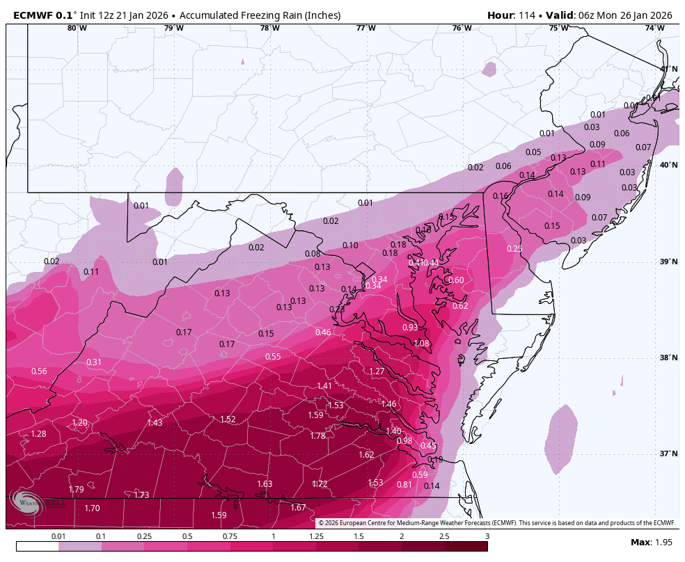
Anonymous
Anonymous wrote:
Anonymous wrote:
Anonymous wrote:
Anonymous wrote:
Anonymous wrote:Any updates to the forecast yet today?

GFS model, which was the outlier that had the storm running to the south (meaning little to no accumulation) has updated and is now tracking higher snow totals similar to other models.


So 2 feet or so?


Currently showing 16 in within the beltway IF its all snow and not a mix.


How could we even get a mix with how cold the temps will be?


Doug Kammerer is now saying there’s likely to be mixing up through Montgomery County, likely more sleet than freezing rain.

Even though it will be super cold, he said a layer of warmish air might ride up over the cold air, so that snow would melt in the warmish air and then refreeze into ice as it hits the cold air closer to the ground. That’s the absolute worst scenario.
Anonymous
Anonymous wrote:
Anonymous wrote:
Anonymous wrote:
Anonymous wrote:
Anonymous wrote:
Anonymous wrote:Any updates to the forecast yet today?

GFS model, which was the outlier that had the storm running to the south (meaning little to no accumulation) has updated and is now tracking higher snow totals similar to other models.


So 2 feet or so?


Currently showing 16 in within the beltway IF its all snow and not a mix.


How could we even get a mix with how cold the temps will be?


Doug Kammerer is now saying there’s likely to be mixing up through Montgomery County, likely more sleet than freezing rain.

Even though it will be super cold, he said a layer of warmish air might ride up over the cold air, so that snow would melt in the warmish air and then refreeze into ice as it hits the cold air closer to the ground. That’s the absolute worst scenario.


OP here. Nothing is set in stone yet. We're going to have a better idea of where things stand tomorrow and Friday.
Anonymous
Anonymous wrote:The chances of roads being drivable Monday are non-existent?


Extremely cold temperatures for the next week make it unlikely any snow will melt, plus anything that melts will refreeze. But it all depends on how much snow there is.
post reply Forum Index » Environment, Weather, and Green Living
Message Quick Reply
Go to: