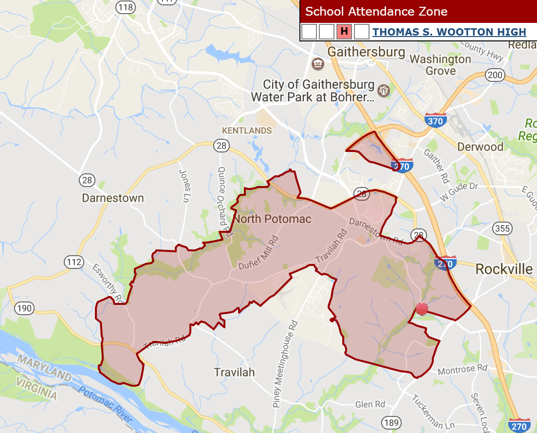
MCPS High School Boundary Map? Current.

Anonymous

And this is Churchhill, you can barely see the purple icon for the HS but it is there..

Anonymous
This webstie is dated 2011 but it tells about the same issues..
There are lots of maps, graphs and other stuff that provides an interesting overview of the problems .

GISCorps Projects, Social Justice, Spatial Analysis August 21, 2011
Volunteering with a non profit organization in Montgomery County, MD

[i]
GISCorps assisted a US based nonprofit organization, Identity Inc., with analyzing and mapping a variety of demographic and financial data of both upper and lower income school communities in Montgomery County, Maryland. The project was designed to address the issue of social justice within Montgomery County. There is a significant gap between upper and lower income classes in the county and most middle/upper income families strive to live in the community with the best possible schools. The Montgomery County district is divided into high school “clusters” which contain middle and elementary schools in a hierarchical spatial structure. The allocation of resources in such a system may not equitably distribute resources within the entire district.

Montgomery County is very diverse in many ways, ranging from urban to rural areas, and its demographics reflect this diversity. Only 4.3% of the county is under the national poverty line, compared to 14.3% for the United States. The Gini coefficient statistic is a standard measure of income inequality and ranges from 0 for absolute equality to 100 where one household has all the income. Using household income from the Census Bureau’s 2007-2009 American Community Survey, we find that the coefficient for Montgomery County is 66.1 and is much higher than the national coefficient of 45.4. Thus there is a high degree of household income inequality in the county.


53% of all county income is earned by the top quarter, the bottom quarter earn only 6%


This project demonstrates how Montgomery County can identify and mitigate social injustices occurring within their boundaries. The four components to the project are: 1) identify community-level economic elements affecting lower income families, 2) design an analytical framework to understand community and income-based economic conditions, 3) apply the framework to analyze conditions in Montgomery County, and 4) recommend policies and actions for mitigating adverse effects.As a first step, it was important to understand what data were available, which, as experienced GIS professionals know, can be the most time-consuming project task. Finding consistent data that identify community-level economic elements affecting lower income families is a cumbersome task. The Montgomery County School Board provided the shape files of their school catchment zones as well as school locations. The Nielsen Company provided demographics at a block group level (gratis) so the data could be aggregated to the high school clusters (see map). County level budget data and locations were provided by county agencies and aggregated to the same level. Other data were reviewed and are either in the process of being incorporated or have been ruled out due to the inability to measure across school zones.
The next step was to design an analytical framework to understand community and income-based economic conditions. The analysis was performed at the high school cluster level. Elementary and middle school zones are too small to accurately aggregate the data. The definition of lower income was adjusted for Montgomery County due to the cost of living and its proximity to a major metropolitan area like Washington, D.C. The break for lower income families was set at a much higher level than would be the case for most communities.
Montgomery County Public Schools (MCPS) labeled elementary schools with large populations of students w/“unique needs” and poor performance (economic & educational challenges) as “Red Zone” beginning in 1999 and those without as “Green Zone”.

Demographic and socioeconomic data were summarized by the three zones.

The high school clusters are not completely aligned with the block groups, so proportional aggregation was used to produce estimates. Therefore, the demographics were not as flexible in providing the breaks desired (e.g., how many owned households with children and had an income under $50,000 within each SCC).
Budget data was the next part of the framework to be added. Gathering this data and attempting to find the actual locations where funds are expended is extremely challenging.
Blue dots graduated by budget value


Once the points were created, the individual items were parsed into either county-wide, cross district, or individual districts, depending upon the benefit level to the county or specific area.
The CIP earmarks show a bias towards GZ SSARs.

A strategy to improve equitable distribution of the district’s resources was also developed and includes suggesting implementation of the following:
1) Common budgeting framework with more equitable resource allocation through community and income-based HHs focused budgeting2) Land Use Planning sensitive to the geographic basis of household socio-economic class 3) Tax incentives for Red Zone investment and development
Also suggested is development of Matrix Management or Horizontal Linkages to allow comprehensive and more equitable planning and resource decisions.
The final task in the project was to present the data to the county. A slide show was produced to help explain the issue and present the data and findings. The objectives is to begin gaining support from other organizations within the county and then make a presentation as a group directly to the county concerning possible solutions in more equitably allocating school district resources in the county.[/i]
Anonymous
clicked to soon

HERE IS the Source LINK FOR THE ABOVE:

https://www.giscorps.org/identity_069/
Anonymous
Anonymous wrote:
Anonymous wrote:
Anonymous wrote:
Anonymous wrote:
Anonymous wrote:In whole honesty some of the current boundaries are interesting. I am sure there must be some logic
to them but it is kind puzzling why some schools is so marginally located while others are more centrally located.
It seems logical that boundary change could minimize or at least balance bussing and reduce footprint right?

Just random examples

Wootton: (Wootton HS is that red dot) and that little floating triangular is also part of the boundary???


Blair: (Blair HS is that purple icon) also rather not centrally located.


Whitman - definitely more centrally located then the two above,


Rockville High


The fix for Whitman is pretty obvious - Carderock (outside the beltway) should go to Churchill in Potomac. Westbrook (currently at BCC) could fill in for Carderock at Whitman. This would help alleviate space concerns at Whitman and BCC, and cut down on busing to both schools. In addition, BCC would become marginally more diverse, with no real change to Churchill or Whitman.

Wootton is really odd. A portion of the border near the river is a historically African American community (Tobytown) that is much closer to Churchill. If Tobytown were redistricted to Churchill, that would seem to be a win-win all around from an environmental and equity standpoint. These small boundary tweaks are the things we should be thinking about. I don't think the school board has any interest in busing people from Bethesda to Gaithersburg like some on this board fear.


I'm skeptical of the BOE's intentions, but I agree that, if you need to make changes, the kind you are proposing here make sense.


What "problem" are you fixing at Whitman?

Also, this "solution" would put BCC on the far edge of (and actually outside of) its own service area - exactly the type of thing that is supposedly a problem with other schools.

Hard pass.


You don't know the BCC service area. BCC is actually one of the most sensibly drawn school boundary right now. But it can't accommodate many more students and there is no additional space for additions. BCC is exactly between 4 of the elementary schools (Bethesda, Chevy Chase, North Chevy Chase and Somerset), with Westbrook, Rock Creek Forest and Rosemary Hills off to the side). For reasons discussed ad nauseam on this board related to equity, it makes no sense to move the less affluent neighborhoods of RCF or Rosemary Hills away from BCC, which is otherwise an extremely wealth cluster. But Westbrook, which is closer to Whitman than BCC and is also very wealthy, could easily be moved. Carderock is outside the beltway and it could potentially cut down on transportation costs and environmental impact to move it to Churchill.


I am very familiar with BCC's service area. The PP suggested moving Westland from BCC to Whitman. Westland includes Westbrook, Somerset, and Bethesda Elementary. That would create an unbalanced district, with BCC on the far edge of the service area, and actually outside of it (since it is in the Bethesda Elementary service area).

If you meant to suggest moving Westbrook, then yes, that would work as you suggested. (Though I hope it doesn't happen, since we are in the Westbrook area, and much prefer BCC.) But you still haven't identified what problem you are seeking to address re Whitman.

Anonymous
Anonymous wrote:
Also, this "solution" would put BCC on the far edge of (and actually outside of) its own service area - exactly the type of thing that is supposedly a problem with other schools.

This is just not correct.


Really? If Westland is moved to Whitman, that means Westbrook, Somerset and Bethesda Elementary are moved. BCC is in the Bethesda Elementary service area.

What's not correct?
Anonymous
Anonymous wrote:
Anonymous wrote:
Anonymous wrote:
Anonymous wrote:
Anonymous wrote:
Anonymous wrote:In whole honesty some of the current boundaries are interesting. I am sure there must be some logic
to them but it is kind puzzling why some schools is so marginally located while others are more centrally located.
It seems logical that boundary change could minimize or at least balance bussing and reduce footprint right?

Just random examples

Wootton: (Wootton HS is that red dot) and that little floating triangular is also part of the boundary???


Blair: (Blair HS is that purple icon) also rather not centrally located.


Whitman - definitely more centrally located then the two above,


Rockville High


The fix for Whitman is pretty obvious - Carderock (outside the beltway) should go to Churchill in Potomac. Westbrook (currently at BCC) could fill in for Carderock at Whitman. This would help alleviate space concerns at Whitman and BCC, and cut down on busing to both schools. In addition, BCC would become marginally more diverse, with no real change to Churchill or Whitman.

Wootton is really odd. A portion of the border near the river is a historically African American community (Tobytown) that is much closer to Churchill. If Tobytown were redistricted to Churchill, that would seem to be a win-win all around from an environmental and equity standpoint. These small boundary tweaks are the things we should be thinking about. I don't think the school board has any interest in busing people from Bethesda to Gaithersburg like some on this board fear.


I'm skeptical of the BOE's intentions, but I agree that, if you need to make changes, the kind you are proposing here make sense.


What "problem" are you fixing at Whitman?

Also, this "solution" would put BCC on the far edge of (and actually outside of) its own service area - exactly the type of thing that is supposedly a problem with other schools.

Hard pass.


You don't know the BCC service area. BCC is actually one of the most sensibly drawn school boundary right now. But it can't accommodate many more students and there is no additional space for additions. BCC is exactly between 4 of the elementary schools (Bethesda, Chevy Chase, North Chevy Chase and Somerset), with Westbrook, Rock Creek Forest and Rosemary Hills off to the side). For reasons discussed ad nauseam on this board related to equity, it makes no sense to move the less affluent neighborhoods of RCF or Rosemary Hills away from BCC, which is otherwise an extremely wealth cluster. But Westbrook, which is closer to Whitman than BCC and is also very wealthy, could easily be moved. Carderock is outside the beltway and it could potentially cut down on transportation costs and environmental impact to move it to Churchill.


I am very familiar with BCC's service area. The PP suggested moving Westland from BCC to Whitman. Westland includes Westbrook, Somerset, and Bethesda Elementary. That would create an unbalanced district, with BCC on the far edge of the service area, and actually outside of it (since it is in the Bethesda Elementary service area).

If you meant to suggest moving Westbrook, then yes, that would work as you suggested. (Though I hope it doesn't happen, since we are in the Westbrook area, and much prefer BCC.) But you still haven't identified what problem you are seeking to address re Whitman.


Oops, I see now I misread. Sorry!

But, I am still interested in what problem with Whitman this remedies.
Anonymous
Anonymous wrote:
Anonymous wrote:
Also, this "solution" would put BCC on the far edge of (and actually outside of) its own service area - exactly the type of thing that is supposedly a problem with other schools.

This is just not correct.


Really? If Westland is moved to Whitman, that means Westbrook, Somerset and Bethesda Elementary are moved. BCC is in the Bethesda Elementary service area.

What's not correct?


Oops, my mistake, I read Westland for Westbrook.
Anonymous
Anonymous wrote:
Anonymous wrote:
Anonymous wrote:
Anonymous wrote:
Anonymous wrote:
Anonymous wrote:In whole honesty some of the current boundaries are interesting. I am sure there must be some logic
to them but it is kind puzzling why some schools is so marginally located while others are more centrally located.
It seems logical that boundary change could minimize or at least balance bussing and reduce footprint right?

Just random examples

Wootton: (Wootton HS is that red dot) and that little floating triangular is also part of the boundary???


Blair: (Blair HS is that purple icon) also rather not centrally located.


Whitman - definitely more centrally located then the two above,


Rockville High


The fix for Whitman is pretty obvious - Carderock (outside the beltway) should go to Churchill in Potomac. Westbrook (currently at BCC) could fill in for Carderock at Whitman. This would help alleviate space concerns at Whitman and BCC, and cut down on busing to both schools. In addition, BCC would become marginally more diverse, with no real change to Churchill or Whitman.

Wootton is really odd. A portion of the border near the river is a historically African American community (Tobytown) that is much closer to Churchill. If Tobytown were redistricted to Churchill, that would seem to be a win-win all around from an environmental and equity standpoint. These small boundary tweaks are the things we should be thinking about. I don't think the school board has any interest in busing people from Bethesda to Gaithersburg like some on this board fear.


I'm skeptical of the BOE's intentions, but I agree that, if you need to make changes, the kind you are proposing here make sense.


What "problem" are you fixing at Whitman?

Also, this "solution" would put BCC on the far edge of (and actually outside of) its own service area - exactly the type of thing that is supposedly a problem with other schools.

Hard pass.


You don't know the BCC service area. BCC is actually one of the most sensibly drawn school boundary right now. But it can't accommodate many more students and there is no additional space for additions. BCC is exactly between 4 of the elementary schools (Bethesda, Chevy Chase, North Chevy Chase and Somerset), with Westbrook, Rock Creek Forest and Rosemary Hills off to the side). For reasons discussed ad nauseam on this board related to equity, it makes no sense to move the less affluent neighborhoods of RCF or Rosemary Hills away from BCC, which is otherwise an extremely wealth cluster. But Westbrook, which is closer to Whitman than BCC and is also very wealthy, could easily be moved. Carderock is outside the beltway and it could potentially cut down on transportation costs and environmental impact to move it to Churchill.


I am very familiar with BCC's service area. The PP suggested moving Westland from BCC to Whitman. Westland includes Westbrook, Somerset, and Bethesda Elementary. That would create an unbalanced district, with BCC on the far edge of the service area, and actually outside of it (since it is in the Bethesda Elementary service area).

If you meant to suggest moving Westbrook, then yes, that would work as you suggested. (Though I hope it doesn't happen, since we are in the Westbrook area, and much prefer BCC.) But you still haven't identified what problem you are seeking to address re Whitman.


Nobody except you said Westland - WestBROOK.
Anonymous
Anonymous wrote:
Anonymous wrote:
Anonymous wrote:
Anonymous wrote:
Anonymous wrote:
Anonymous wrote:
Anonymous wrote:In whole honesty some of the current boundaries are interesting. I am sure there must be some logic
to them but it is kind puzzling why some schools is so marginally located while others are more centrally located.
It seems logical that boundary change could minimize or at least balance bussing and reduce footprint right?

Just random examples

Wootton: (Wootton HS is that red dot) and that little floating triangular is also part of the boundary???


Blair: (Blair HS is that purple icon) also rather not centrally located.


Whitman - definitely more centrally located then the two above,


Rockville High


The fix for Whitman is pretty obvious - Carderock (outside the beltway) should go to Churchill in Potomac. Westbrook (currently at BCC) could fill in for Carderock at Whitman. This would help alleviate space concerns at Whitman and BCC, and cut down on busing to both schools. In addition, BCC would become marginally more diverse, with no real change to Churchill or Whitman.

Wootton is really odd. A portion of the border near the river is a historically African American community (Tobytown) that is much closer to Churchill. If Tobytown were redistricted to Churchill, that would seem to be a win-win all around from an environmental and equity standpoint. These small boundary tweaks are the things we should be thinking about. I don't think the school board has any interest in busing people from Bethesda to Gaithersburg like some on this board fear.


I'm skeptical of the BOE's intentions, but I agree that, if you need to make changes, the kind you are proposing here make sense.


What "problem" are you fixing at Whitman?

Also, this "solution" would put BCC on the far edge of (and actually outside of) its own service area - exactly the type of thing that is supposedly a problem with other schools.

Hard pass.


You don't know the BCC service area. BCC is actually one of the most sensibly drawn school boundary right now. But it can't accommodate many more students and there is no additional space for additions. BCC is exactly between 4 of the elementary schools (Bethesda, Chevy Chase, North Chevy Chase and Somerset), with Westbrook, Rock Creek Forest and Rosemary Hills off to the side). For reasons discussed ad nauseam on this board related to equity, it makes no sense to move the less affluent neighborhoods of RCF or Rosemary Hills away from BCC, which is otherwise an extremely wealth cluster. But Westbrook, which is closer to Whitman than BCC and is also very wealthy, could easily be moved. Carderock is outside the beltway and it could potentially cut down on transportation costs and environmental impact to move it to Churchill.


I am very familiar with BCC's service area. The PP suggested moving Westland from BCC to Whitman. Westland includes Westbrook, Somerset, and Bethesda Elementary. That would create an unbalanced district, with BCC on the far edge of the service area, and actually outside of it (since it is in the Bethesda Elementary service area).

If you meant to suggest moving Westbrook, then yes, that would work as you suggested. (Though I hope it doesn't happen, since we are in the Westbrook area, and much prefer BCC.) But you still haven't identified what problem you are seeking to address re Whitman.


Oops, I see now I misread. Sorry!

But, I am still interested in what problem with Whitman this remedies.


Not really about remediating Whitman’s problems. Whitman has more ability to grow than BCC, so it helps BCC by taking out an elemtary school. And it saves on transportation costs.
Anonymous
Anonymous wrote:
Anonymous wrote:

But, I am still interested in what problem with Whitman this remedies.


Not really about remediating Whitman’s problems. Whitman has more ability to grow than BCC, so it helps BCC by taking out an elemtary school. And it saves on transportation costs.


If they did move Westbrook to Whitman, it would still make sense for Westbrook to articulate to Westland first, since it's right there. And there wouldn't be room at Pyle anyway, even after the addition opens.
Anonymous
Anonymous wrote:
Anonymous wrote:
Anonymous wrote:
Anonymous wrote:Somebody recently made this version which overlays FARMS percentages in clusters. It is quite telling, and you can see where there can be some movement. It is pretty obvious which schools will be tough to bus due to long commutes to higher FARMS rate schools. I just don't see how they are going to create any diversity with those schools....they look pretty protected to me. https://www.arcgis.com/apps/InteractiveLegend/index.html?appid=bf5860e2422b4816970eb80960f8019c&fbclid=IwAR0tlyWCuePkw9oJ3Wemm-jWQ7XUFLZ07awWNytnq2WhjUGBJ5oPH8CUcm4


Fascinating map, thanks for sharing.


Is it? Did anyone dispute that the poor minorities lived on the east side of town? Did anyone dispute that when there are concentrations of poor people that people with money avoid that area? When the rich flood to an area prices go up and poor people can’t move there so the select the cheap side of town. Those areas get more poverty which causes flight and here we are

DP.. yes, it is a fascinating map. Visuals are always better than words. It also shows that there are a couple of clusters where the FARMs rate is more equitable- those that are about 20 to 30%.


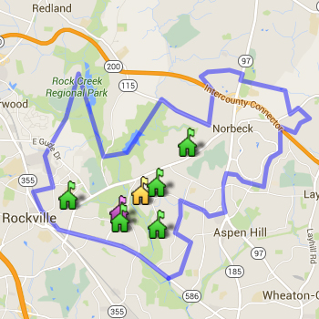
It's not as useful because it simply colors in the boundaries with the FARMS rate for the school, rather than showing the variation inside the cluster and places where you could move neighborhoods. But, I appreciate the person who made it.
Anonymous
Anonymous wrote:
Anonymous wrote:
Anonymous wrote:

But, I am still interested in what problem with Whitman this remedies.


Not really about remediating Whitman’s problems. Whitman has more ability to grow than BCC, so it helps BCC by taking out an elemtary school. And it saves on transportation costs.


If they did move Westbrook to Whitman, it would still make sense for Westbrook to articulate to Westland first, since it's right there. And there wouldn't be room at Pyle anyway, even after the addition opens.


I am not sure what would be accomplished by moving Westbreeok into Whitman, anyway - making space at BCC? They are about to expand Westbrook to reshuffle kids from Somerset over there. There is no room to expand Somerset. And they are explanding both Pyle and Whitman, but I don't think they have enough space to add a whole 'nother elementary school after that expansion.
Anonymous
Anonymous wrote:In whole honesty some of the current boundaries are interesting. I am sure there must be some logic
to them but it is kind puzzling why some schools is so marginally located while others are more centrally located.
It seems logical that boundary change could minimize or at least balance bussing and reduce footprint right?

Just random examples

Wootton: (Wootton HS is that red dot) and that little floating triangular is also part of the boundary???


Yeah talk about some crazy gerrymandering.

It's amazing to me that you have household and Silver Spring that are within walking distance of Blair high school and are districted omewhere else.

I am in boundary for New Hampshire estates and there are no less than three elementary schools that are physically closer to our house then New Hampshire estates
Blair: (Blair HS is that purple icon) also rather not centrally located.


Whitman - definitely more centrally located then the two above,


Rockville High


Anonymous
Anonymous wrote:
Anonymous wrote:
Anonymous wrote:

But, I am still interested in what problem with Whitman this remedies.


Not really about remediating Whitman’s problems. Whitman has more ability to grow than BCC, so it helps BCC by taking out an elemtary school. And it saves on transportation costs.


If they did move Westbrook to Whitman, it would still make sense for Westbrook to articulate to Westland first, since it's right there. And there wouldn't be room at Pyle anyway, even after the addition opens.


There would be room at Pyle, because Carderock would be moved out (or maybe Bradley Hils to Walter Johnson/Woodward).
Anonymous
Anonymous wrote:
Anonymous wrote:
Anonymous wrote:
Anonymous wrote:

But, I am still interested in what problem with Whitman this remedies.


Not really about remediating Whitman’s problems. Whitman has more ability to grow than BCC, so it helps BCC by taking out an elemtary school. And it saves on transportation costs.


If they did move Westbrook to Whitman, it would still make sense for Westbrook to articulate to Westland first, since it's right there. And there wouldn't be room at Pyle anyway, even after the addition opens.


I am not sure what would be accomplished by moving Westbreeok into Whitman, anyway - making space at BCC? They are about to expand Westbrook to reshuffle kids from Somerset over there. There is no room to expand Somerset. And they are explanding both Pyle and Whitman, but I don't think they have enough space to add a whole 'nother elementary school after that expansion.


Yeah, but they can and should take out one of the elementary schools from Whitman. Carderock is outside the beltway, and Bradley Hills should probably be in the conversation for the Woodward re-opening. These could easily be removed from Whitman.
post reply Forum Index » Montgomery County Public Schools (MCPS)
Message Quick Reply
Go to: