Inner Loop and Outer Loop of the Beltway Meaning.
Anonymous
Using this map:
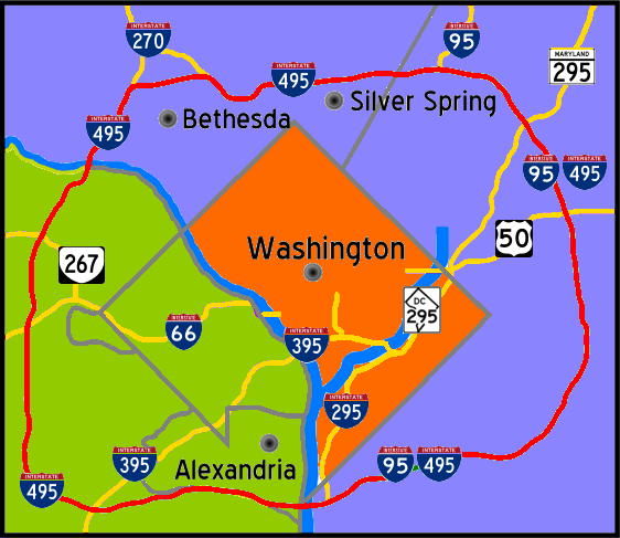
Left side(Bethesda and Alexandria) is outer loop. Right side (Silver Spring) is inner loop. Is this correct? |
Anonymous
| Picture the road in your head. There are actually two roads side by side, one going one direction and one going the other. Two loops, if you will. The inner loop is the one closer to the city and the outer loop is further away. |
Anonymous
| Outer loop counter clockwise. Inner loop clockwise. Easy. |
Anonymous
+1 |
Anonymous
They do this because it doesn’t make sense to use north/south/east/west on a road that goes in a circle. |
Anonymous
This. You are on the outer loop if you are driving on the lanes on the outside of the loop/circle. (DC is to your left) You are on the inner loop if you are driving on the lanes on the inside of the loop/circle. (MD/VA outer burbs are to the left of you) |
Anonymous
| How people don’t get which is the inner and which is the outer blows my mind. Makes me fear for the future if this country. |
Anonymous
If you are new to the area, it’s not exactly obvious !! |
Anonymous
This is a better visual

|
Anonymous
| When I drive from Alexandria to Bethesda via Tysons I’m on the inner loop. When I return from Bethesda via Tysons to Alexandria I’m now on the outer loop. |
Anonymous
It's not obvious when you're driving if you're new to the area. It should be obvious when looking at a traditional map. |
Anonymous
| Inner loop is closer to the city and outer loop is closer to the suburbs |
Anonymous
You don’t need a map to understand the meanings of the words “inner” and “outer.” DC is not the only city with an inner loop and an outer loop. They mean the same thing in regards to all of the cities that have them. |
Anonymous
| It is a little troubling that this is in question to some. |
Anonymous
That's not true. In Houston, there are two actual full beltways. The inner loop is I-610 a full loop around the city and includes both directions and is closer to the city center (the blue loop). The outer loop is Beltway 8 (TX-8), another full loop that includes both directions and is further out from the city (the red loop). 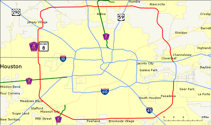
|