National Weather Service statement for Friday's potential snow and ice
Anonymous
|
Special Weather Statement
National Weather Service Baltimore MD/Washington DC 750 AM EST Thu Dec 4 2025 DCZ001-MDZ004>006-008-011-013-014-016>018-503>508-VAZ053>055-501- 502-505-506-526-527-041900- District of Columbia-Frederick MD-Carroll-Northern Baltimore- Cecil-Southern Baltimore-Prince Georges-Anne Arundel-Charles- St. Marys-Calvert-Northwest Montgomery- Central and Southeast Montgomery-Northwest Howard- Central and Southeast Howard-Northwest Harford-Southeast Harford- Fairfax-Arlington/Falls Church/Alexandria-Stafford- Northern Fauquier-Southern Fauquier-Western Loudoun- Eastern Loudoun-Northwest Prince William- Central and Southeast Prince William/Manassas/Manassas Park- Including the cities of Washington, Frederick, Ballenger Creek, Eldersburg, Westminster, Reisterstown, Cockeysville, Elkton, Baltimore, Bowie, Suitland-Silver Hill, Clinton, College Park, Greenbelt, Laurel, Camp Springs, Glen Burnie, Annapolis, Severn, South Gate, Severna Park, Arnold, Odenton, St. Charles, Waldorf, Lexington Park, California, Chesapeake Beach, Huntingtown, Dunkirk, North Beach, Lusby, Prince Frederick, Germantown, Damascus, Bethesda, Rockville, Gaithersburg, Silver Spring, Lisbon, Columbia, Ellicott City, Jarrettsville, Aberdeen, Reston, Herndon, Annandale, Centreville, Chantilly, McLean, Franconia, Arlington, Alexandria, Falls Church, Falmouth, Warrenton, Turnbull, Purcellville, Leesburg, Ashburn, Sterling, Haymarket, Dale City, Manassas, Woodbridge, Lake Ridge, and Montclair 750 AM EST Thu Dec 4 2025 ...POTENTIAL WINTER COMMUTING HAZARD FOR THE BALTIMORE/ WASHINGTON METRO AREAS FRIDAY MORNING... There is a potential for hazardous commuting conditions for the Friday morning commute. A period of light snow is POSSIBLE (a 30 to 50 percent chance) Friday morning across the Baltimore/Washington DC metro areas with up to an inch of snow possible accumulation on untreated roadways. If this threat does materialize during the Friday morning rush hour, many roads could quickly turn icy. This could lead to dangerous traveling conditions, multiple accidents, and extensive delays. If commuting Friday morning, be aware of the POSSIBILITY of significant travel disruptions. Plan ahead by allowing for extra travel time, and consider using public transportation and telework options. In addition, light snow or freezing drizzle accumulations may also impact the evening commute as the storm system is slow to depart late Friday afternoon and evening. Stay tuned for updates on this potential winter weather episode. |
Anonymous

|
Anonymous
| Ugh. I'm flying out of Reagan tomorrow afternoon. Boo snow! |
Anonymous
|
Upgraded to Winter Weather Advisory.
|
Anonymous
Ugh I have Mohs surgery tomorrow afternoon. Boo snow! |
Anonymous
|
Anonymous
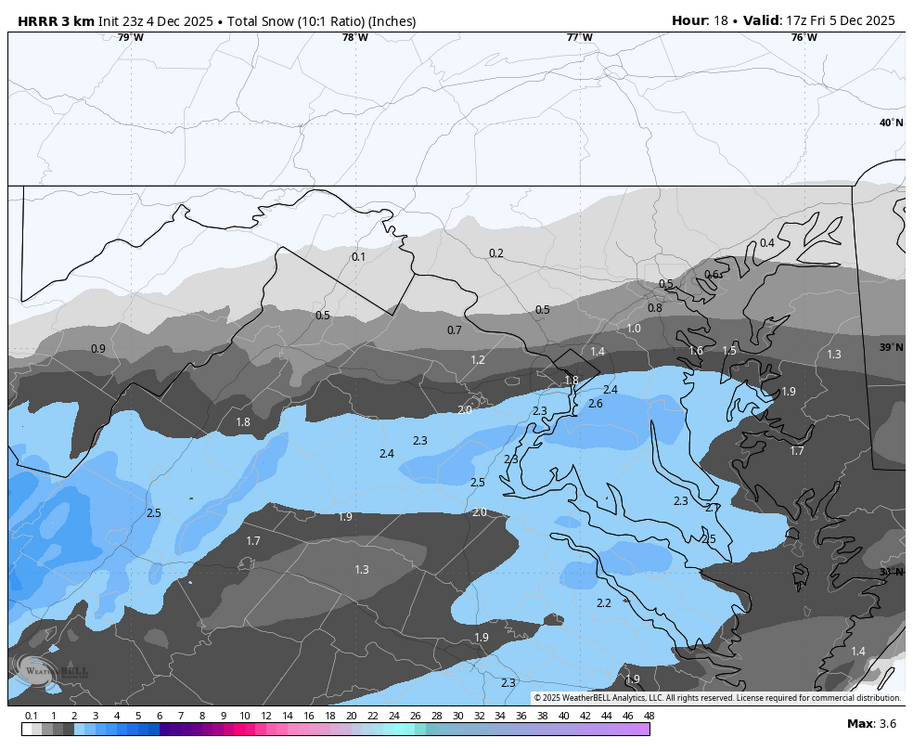
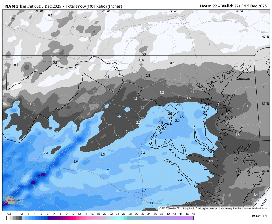
Capital Weather Gang has increased their totals slightly to align with the rest of the models:

|
Anonymous
Tonight models are starting to get a little more exciting
|
Anonymous
| S’now big deal. |