Montgomery County Redistricting
Anonymous
|
https://www.montgomerycountymd.gov/COUNCIL/BCC/redistricting/
Proposed map with the creation of 2 new districts. Don't know why they couldn't overlay over the existing districts so one could easily see the change. Pretty clearly racially gerrymandered. I mean, shouldn't districts at least be one contiguous area? At least do the thing where you have some narrow corridor connecting, for instance, Kensington and Takoma Park. |
Anonymous
There are no districts that are not contiguous.
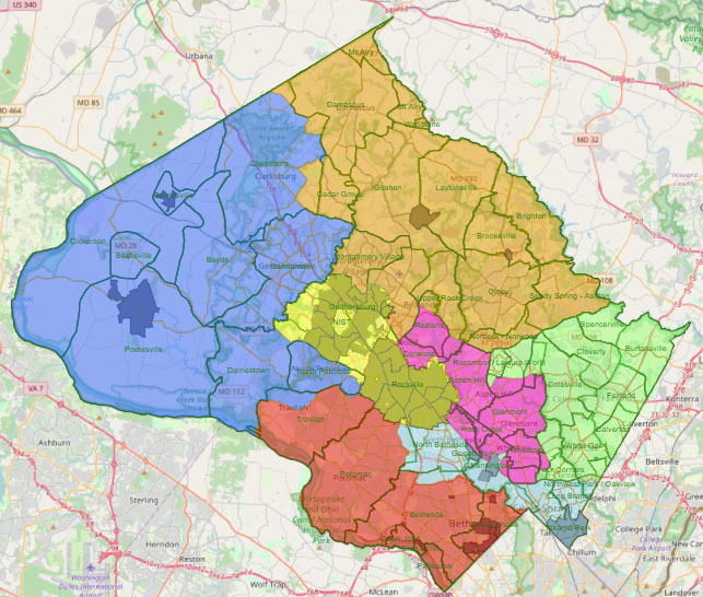
And I don’t know why you think it’s racially gerrymandered. |
Anonymous
Look closer. There are 5 non-contiguous districts. That yellow area covering Rockville/Gaithersburg is split up into like 8-9 areas. Some seem to cover maybe a couple blocks. This WP article makes it pretty clear that the goal, of at least some of the panel, was to increase racial diversity on the council. It was a 6-5 vote, so obviously fairly contentious. https://www.washingtonpost.com/dc-md-va/2021/10/21/montgomery-county-redistricting-election/ “This map tells the story of Montgomery County,” said Ervin, who represented District 5 from 2006 to 2014. “Hopefully, an outgrowth of this map is that we’ll see more people running for council seats who we haven’t seen before. … More Latino candidates, more Asian candidates, more Black candidates — that would be the best outcome of all.” |
Anonymous
I’m pretty sure you’re wrong. The darker overlays in each district are the municipalities. All the yellow color is one district and the darker yellow areas in it are the cities of Rockville and Gaithersburg that are part of that district. |
Anonymous
| Now I’m sure you’re wrong since you didn’t come back and defend your knee-jerk response to what is a pretty good map. Clarksburg wanted their own district and got it. Bethesda, Chevy Chase and Potomac didn’t want to be lumped in with the Ag Reserve (which was done 30 years ago to combine the districts of the two Republicans who were on the Council at the time into one - one of the ended up moving. 😀) East County wanted their own district and got it. The North Bethesda to Takoma Park district makes sense because they are all inner ring densely populated suburbs with similar goals/issues etc. Regarding the two majority Black and Hispanic districts, that’s something that has always been encouraged by the Voting Rights Act. I don’t think the VRA applies to councilmanic districts within states but obviously the majority of the panel thought it was a good philosophy to follow. |
Anonymous
|
Yes, the "it's gerrymandered" PP is just wrong. Though I agree that it's visually confusing to have the municipal boundaries overlayed on the proposed district boundaries.
Also, Clarksburg does not have its own district; that district also includes most of Germantown. |
Anonymous
Good point. Germantown has more in common with Gaithersburg but they’re both too big to combine. But lots of the same issues as 270 corridor exurbs with not a lot of mass transit. This makes so much more sense than the current districts below. Poolesville and Chevy Chase have nothing in common. Laytonsville and Wheaton have nothing in common. Burtonsville has gotten no attention for years because it was lumped in with downtown Silver Spring and Takoma Park. 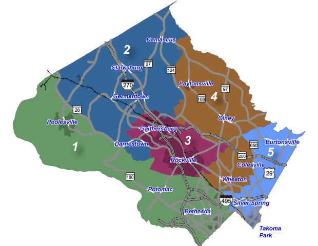
|
Anonymous
|
I don't care about race, personally. I'm in Derwood, though, and don't want to be with a huge number of super-progressives. I don't think that's going to happen with Aspen Hill and Wheaton. At least not now. But Wheaton is gentrifying and will likely bring more progressives. I am a more moderate liberal and would like my district to be more moderate, and balance out the progressive at-large councilmembers.
Overall, though, the map seems fine to me. |
Anonymous
It wasn't done 30 years ago. It was done 10 years ago when Berliner was in office. |
Anonymous
Yes, I like the switch from 5 districts to 7. Even with 7 districts, it's still about 160,000 people per district, but that's better than 220,000. I know people in the rural western county who will complain that they're still not getting a real upcounty representative, but the numbers are not on their side. Plus, also, I'm pretty sure I know what they mean by "real upcounty." |
Anonymous
|
So... what change will this bring about, exactly? |
Anonymous
Can someone explain why the arson darker shaded areas within the districts? For example Rockville has some neon green and then muddy green areas. But I agree, this makes much more sense then the previous map. |
Anonymous
The bigger impact is having 11 council members rather than 9. That was the alternative Evan Glass proposed rather than lose any at-large representation. The council doesn't want to lose its at-large seats because those ensure a very progressive majority on the council. They will claim a desire for racial and ethnic representation in the districts, but it's really about ensuring a progressive majority. |
Anonymous
Incorporated towns like Chevy Chase, Poolesville, Laytonsville, Takoma Park, Gaithersburg, Rockville. |
Anonymous
Whatever Evan Glass's motivation may or may not have been: -the motivation for abolishing the at-large seats was reducing the representation from the more populous, more-likely-to-vote downcounty areas on the county council -my motivation for voting to retain the at-large seats was so that I will still have county council members to contact if my district county council rep is terrible |