Anonymous
This is BCC cluster. It looks reasonably located.

Anonymous
Anonymous wrote:Anonymous wrote:Anonymous wrote:Anonymous wrote:In whole honesty some of the current boundaries are interesting. I am sure there must be some logic
to them but it is kind puzzling why some schools is so marginally located while others are more centrally located.
It seems logical that boundary change could minimize or at least balance bussing and reduce footprint right?
Just random examples
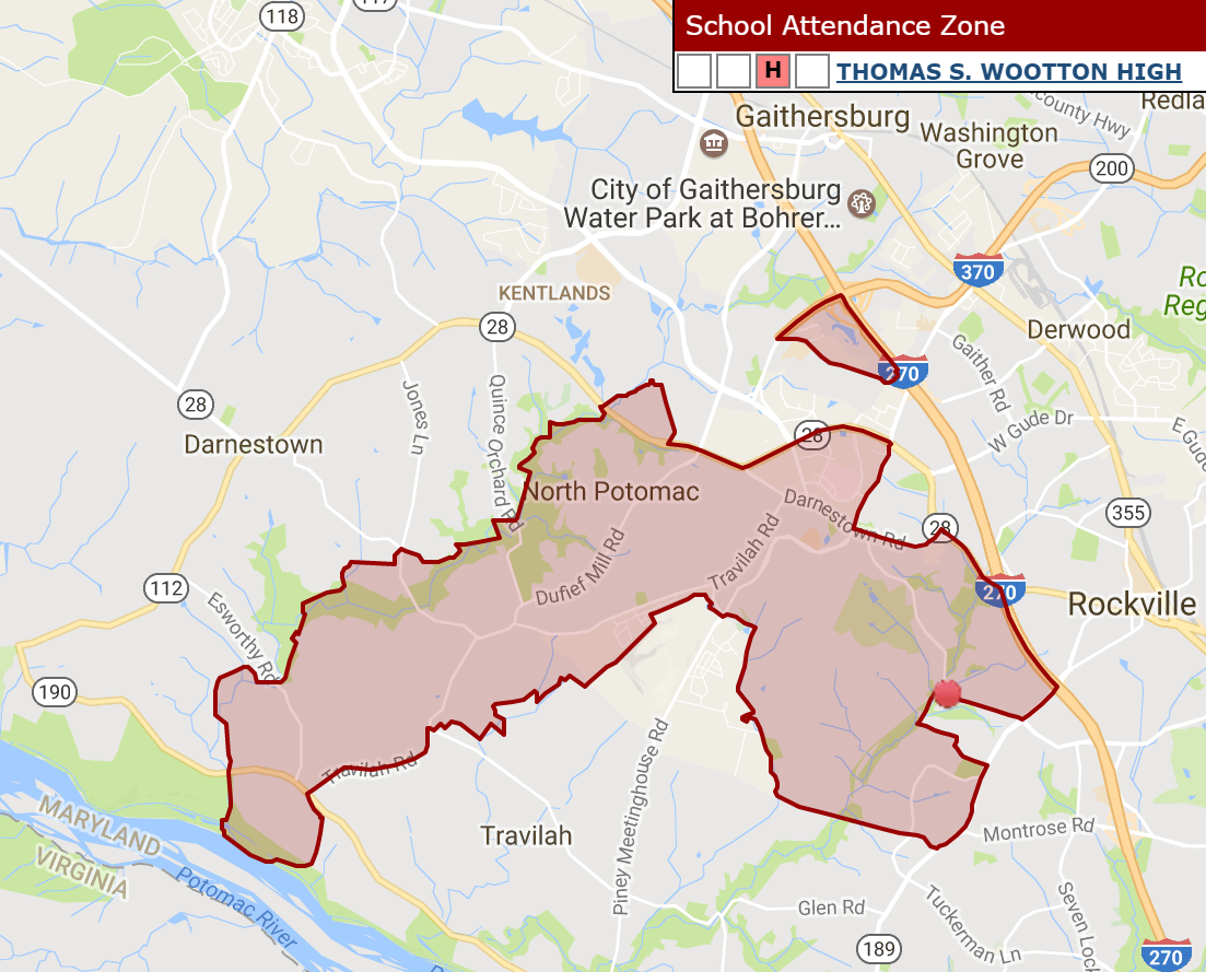
Wootton: (Wootton HS is that red dot) and that little floating triangular is also part of the boundary???
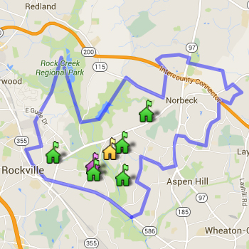
Blair: (Blair HS is that purple icon) also rather not centrally located.

Whitman - definitely more centrally located then the two above,

Rockville High
The fix for Whitman is pretty obvious - Carderock (outside the beltway) should go to Churchill in Potomac. Westbrook (currently at BCC) could fill in for Carderock at Whitman. This would help alleviate space concerns at Whitman and BCC, and cut down on busing to both schools. In addition, BCC would become marginally more diverse, with no real change to Churchill or Whitman.
Wootton is really odd. A portion of the border near the river is a historically African American community (Tobytown) that is much closer to Churchill. If Tobytown were redistricted to Churchill, that would seem to be a win-win all around from an environmental and equity standpoint. These small boundary tweaks are the things we should be thinking about. I don't think the school board has any interest in busing people from Bethesda to Gaithersburg like some on this board fear.
I'm skeptical of the BOE's intentions, but I agree that, if you need to make changes, the kind you are proposing here make sense.
What "problem" are you fixing at Whitman?
Also, this "solution" would put BCC on the far edge of (and actually outside of) its own service area - exactly the type of thing that is supposedly a problem with other schools.
Hard pass.
You don't know the BCC service area. BCC is actually one of the most sensibly drawn school boundary right now. But it can't accommodate many more students and there is no additional space for additions. BCC is exactly between 4 of the elementary schools (Bethesda, Chevy Chase, North Chevy Chase and Somerset), with Westbrook, Rock Creek Forest and Rosemary Hills off to the side). For reasons discussed ad nauseam on this board related to equity, it makes no sense to move the less affluent neighborhoods of RCF or Rosemary Hills away from BCC, which is otherwise an extremely wealth cluster. But Westbrook, which is closer to Whitman than BCC and is also very wealthy, could easily be moved. Carderock is outside the beltway and it could potentially cut down on transportation costs and environmental impact to move it to Churchill.
Anonymous
Also, this "solution" would put BCC on the far edge of (and actually outside of) its own service area - exactly the type of thing that is supposedly a problem with other schools.
This is just not correct.
Anonymous
Anonymous wrote:Anonymous wrote:Anonymous wrote:In whole honesty some of the current boundaries are interesting. I am sure there must be some logic
to them but it is kind puzzling why some schools is so marginally located while others are more centrally located.
It seems logical that boundary change could minimize or at least balance bussing and reduce footprint right?
Just random examples
Wootton: (Wootton HS is that red dot) and that little floating triangular is also part of the boundary???
Blair: (Blair HS is that purple icon) also rather not centrally located.
Whitman - definitely more centrally located then the two above,
Rockville High
The fix for Whitman is pretty obvious - Carderock (outside the beltway) should go to Churchill in Potomac. Westbrook (currently at BCC) could fill in for Carderock at Whitman. This would help alleviate space concerns at Whitman and BCC, and cut down on busing to both schools. In addition, BCC would become marginally more diverse, with no real change to Churchill or Whitman.
Wootton is really odd. A portion of the border near the river is a historically African American community (Tobytown) that is much closer to Churchill. If Tobytown were redistricted to Churchill, that would seem to be a win-win all around from an environmental and equity standpoint. These small boundary tweaks are the things we should be thinking about. I don't think the school board has any interest in busing people from Bethesda to Gaithersburg like some on this board fear.
I'm skeptical of the BOE's intentions, but I agree that, if you need to make changes, the kind you are proposing here make sense.
What "problem" are you fixing at Whitman?
Also, this "solution" would put BCC on the far edge of (and actually outside of) its own service area - exactly the type of thing that is supposedly a problem with other schools.
Hard pass.
Anonymous
Anonymous wrote:Anonymous wrote:In whole honesty some of the current boundaries are interesting. I am sure there must be some logic
to them but it is kind puzzling why some schools is so marginally located while others are more centrally located.
It seems logical that boundary change could minimize or at least balance bussing and reduce footprint right?
Just random examples
Wootton: (Wootton HS is that red dot) and that little floating triangular is also part of the boundary???
Blair: (Blair HS is that purple icon) also rather not centrally located.
Whitman - definitely more centrally located then the two above,
Rockville High
The fix for Whitman is pretty obvious - Carderock (outside the beltway) should go to Churchill in Potomac. Westbrook (currently at BCC) could fill in for Carderock at Whitman. This would help alleviate space concerns at Whitman and BCC, and cut down on busing to both schools. In addition, BCC would become marginally more diverse, with no real change to Churchill or Whitman.
Wootton is really odd. A portion of the border near the river is a historically African American community (Tobytown) that is much closer to Churchill. If Tobytown were redistricted to Churchill, that would seem to be a win-win all around from an environmental and equity standpoint. These small boundary tweaks are the things we should be thinking about. I don't think the school board has any interest in busing people from Bethesda to Gaithersburg like some on this board fear.
I'm skeptical of the BOE's intentions, but I agree that, if you need to make changes, the kind you are proposing here make sense.
Anonymous
Anonymous wrote:Blair: (Blair HS is that purple icon) also rather not centrally located.
This is because the school itself moved but the boundaries did not.
Even after it moved, it was still located solidly within the then-Blair service area:
https://www.montgomeryschoolsmd.org/departments/regulatoryaccountability/glance/fy2004/schools/04757map.pdf
But then Northwood opened and most of the northwestern parts of Blair's area were rezoned there, including the former Blair site itself (now SSIMS/SCES).
Anonymous
Anonymous wrote:In whole honesty some of the current boundaries are interesting. I am sure there must be some logic
to them but it is kind puzzling why some schools is so marginally located while others are more centrally located.
It seems logical that boundary change could minimize or at least balance bussing and reduce footprint right?
Just random examples
Wootton: (Wootton HS is that red dot) and that little floating triangular is also part of the boundary???
Blair: (Blair HS is that purple icon) also rather not centrally located.
Whitman - definitely more centrally located then the two above,
Rockville High
The fix for Whitman is pretty obvious - Carderock (outside the beltway) should go to Churchill in Potomac. Westbrook (currently at BCC) could fill in for Carderock at Whitman. This would help alleviate space concerns at Whitman and BCC, and cut down on busing to both schools. In addition, BCC would become marginally more diverse, with no real change to Churchill or Whitman.
Wootton is really odd. A portion of the border near the river is a historically African American community (Tobytown) that is much closer to Churchill. If Tobytown were redistricted to Churchill, that would seem to be a win-win all around from an environmental and equity standpoint. These small boundary tweaks are the things we should be thinking about. I don't think the school board has any interest in busing people from Bethesda to Gaithersburg like some on this board fear.
Anonymous
Wootton: (Wootton HS is that red dot) and that little floating triangular is also part of the boundary???
This is probably new development that was assigned to Wootton because it was less crowded than the closer/more contiguous high school.
Anonymous
Blair: (Blair HS is that purple icon) also rather not centrally located.
This is because the school itself moved but the boundaries did not.
Anonymous
*why some schools are not is. sorry.
Anonymous
*are centrally..
Anonymous
In whole honesty some of the current boundaries are interesting. I am sure there must be some logic
to them but it is kind puzzling why some schools is so marginally located while others are more centrally located.
It seems logical that boundary change could minimize or at least balance bussing and reduce footprint right?
Just random examples
Wootton: (Wootton HS is that red dot) and that little floating triangular is also part of the boundary???
Blair: (Blair HS is that purple icon) also rather not centrally located.
Whitman - definitely more centrally located then the two above,
Rockville High
Anonymous
Anonymous wrote:Both of these last two posts are implying that they might change ES boundaries. From what I’ve heard, that isn’t on the table.. is it?
Oh, I think it is all on the table, not least because you pretty much NEED to look at ES boundaries to get at HS boundaries, unless you want split articulation at every level. Also, some of the most stark over/under utilization issues are at the ES level.
Anonymous
Anonymous wrote:Anonymous wrote:Anonymous wrote:Anonymous wrote:Anonymous wrote:Somebody recently made this version which overlays FARMS percentages in clusters. It is quite telling, and you can see where there can be some movement. It is pretty obvious which schools will be tough to bus due to long commutes to higher FARMS rate schools. I just don't see how they are going to create any diversity with those schools....they look pretty protected to me. https://www.arcgis.com/apps/InteractiveLegend/index.html?appid=bf5860e2422b4816970eb80960f8019c&fbclid=IwAR0tlyWCuePkw9oJ3Wemm-jWQ7XUFLZ07awWNytnq2WhjUGBJ5oPH8CUcm4
Fascinating map, thanks for sharing.
Is it? Did anyone dispute that the poor minorities lived on the east side of town? Did anyone dispute that when there are concentrations of poor people that people with money avoid that area? When the rich flood to an area prices go up and poor people can’t move there so the select the cheap side of town. Those areas get more poverty which causes flight and here we are
DP.. yes, it is a fascinating map. Visuals are always better than words. It also shows that there are a couple of clusters where the FARMs rate is more equitable- those that are about 20 to 30%.
But that isn’t equitable either, there is more than 20-30% fARMs
There is no way to make everything 100% equitable without cross county busing which NO ONE, including the BOE, is in favor of. But, where it is possible, boundaries can be drawn in certain areas to make it more equitable. 20-30% FARMS is way more equitable than the <5% in some of the W clusters or 50% in some of the east county clusters.
Anonymous
Anonymous wrote:Both of these last two posts are implying that they might change ES boundaries. From what I’ve heard, that isn’t on the table.. is it?
Nobody knows yet. (Other than the boundary studies happening in 2020, for the ESs getting expansions or for the new ESs being built in Gaithersburg and Clarksburg.)